Local State Parks & Forest Service Lands

Pfeiffer Big Sur State Park
Most hikes are through the forest and you are often surrounded by giant redwood trees. A self-guided, quarter-mile Nature Trail is the only ADA-certified trail in the area. The Valley View trail gives you great views of the Lighthouse and the northern coastline, and Buzzard’s Roost is a moderate loop up through the trees with a nice ocean view at the top. For the more adventurous hiker, the Mount Manuel Trail will take you nearly ten miles up to the 3500’ peak. For a leisurely walk along the Big Sur River we recommend Liewald’s Flat which starts just under the bridge across from the Big Sur Lodge restaurant (walk over the bridge then take your first left).
Andrew Molera State Park
(3 miles north) Coastal State Park with bluffs, beaches and headlands where the Big Sur River meets the ocean. The Creamery Meadow Trail is a flat 15-minute walk that gives you direct access to the beach. From there an 8-mile loop of interconnecting trails gives you access to a variety of terrain, including coastal scrub, redwood forest and ridgetop grassland. Spring-Fall there is a foot bridge to cross the Big Sur River to access the beach. Otherwise, you will need to wade across the river to continue on the Creamery Meadow Trail to access the beach and bluff trails.

Julia Pfeiffer Burns State Park
(13.5 miles south) Home of the famous McWay Falls, an 80-foot waterfall that empties directly into the Pacific Ocean. Views of the falls are a short quarter-mile walk from the parking lot. There are also breathtaking ocean vistas from many trails that wind up along the front range of the Santa Lucia Mountains.

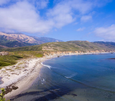
Pfeiffer Beach
(turnoff 2 miles south, at the second 45-mile marker on the west side of Highway 1) Beautiful beach with 3 coves, purple sand and giant rock formations. Entrance off of Highway One on the west side, not well marked. Look for a paved road that goes downhill sharply and has a yellow “Narrow Road – No RVs – No Pedestrians” sign. Only after you turn the first corner on the road you will see a sign for Pfeiffer Beach. It is a 2-mile drive down to the parking lot and you must pay a fee to park. The road is narrow and heavily trafficked, therefore please drive slowly and yield to oncoming traffic.

Point Sur Lighthouse
(5.5 miles north) 3-hour walking tour overlooking the Pacific Ocean with exploration into the Lighthouse and old historic homes and buildings. Tours are first-come, first-served, Saturday & Sunday at 10am and Wednesday at 2pm. (Temporarily closed for construction, see website for additional info) www.pointsur.org (831) 625 4419.

Ventana Wildlife Society Discovery Center
(3 miles north) Located at Andrew Molera State Park. Learn about the history and ecology of the California Condor, which has come back from the brink of extinction due to a captive breeding program and is now flying free once more in the Big Sur wilderness. Open Saturday & Sunday from 10am-4pm from Memorial Day weekend to Labor Day weekend. www.ventanaws.org (831) 620 0702.

Partington Cove
(11.5 miles south) Short hike down a fire road to the rocky mouth of Partington Creek and a small beach, or take the left fork to an historic 60-ft tunnel through the rock and a cove with the rusty ruins of an old ship-loading apparatus, used by the tanoak-logging industry at the turn of the century. There is no signage for Partington on the highway so look for a large U-shaped curve in the road with large dirt turnouts on either side near the 38-mile markers. Across from the Partington Cove fire road, on the East side of Highway 1 you will find the trailhead for a moderately strenuous hike to the Tanbark Trail. This trail takes you to the ruins of the historic Tin House, built in the 1940’s by the previous owners before the land was donated to the state park system. There is a concrete porch with sweeping ocean views to rest and enjoy a picnic lunch.

Garrapata State Park and Beach
(18 miles north) Beautiful long sandy beach, and many coastal hiking trails. Great for picnics, pictures, walking or relaxing with a good book. Trail entrances are scattered along the highway in turnouts on the west side. Look for small brown forest service signs indicating coastal access. Beach access is via a wooden staircase, just north of Garrapata Creek Bridge.

Limekiln State Park
(29 miles south) Slightly off the beaten path, Limekiln is a hidden gem of redwoods, waterfalls, and the cultural history of Big Sur’s lime smelting industry. Hiking trails lead along forest streams to the ruins of the four limekilns, which were active in the late 1800s, and a beautiful waterfall. There is also a small sandy beach beneath the highway where Limekiln Creek empties into the ocean.

Point Lobos State Reserve
(26 miles north of Big Sur Lodge) Beautiful park with hiking trails to hidden coves. You can often see otters, sea lions and seals during your walk along the coastline, and explore the history of archeological sites including the small cabin at Whaler’s Cove that dates from the turn of the century.